Maps are a great way to view the changes to the landscape in and around Timsbury over time. The earliest known detailed map of Timsbury dates from 1784. The Tithe Map of 1838 and later Ordnance Survey maps show the development of the village.
1784 map of Timsbury
The 1784 map is a snapshot of Timsbury at a moment in time. It is a very useful map in that it is detailed and shows the extent of the parish, the buildings and the field patterns. The original surveyor was probably William White and it was copied in 1825 by Thomas Oatley Bennett of Bruton.

Select the map above to see a larger version. The accompaning schedule – Schedule of 1784 map of Timsbury – gives details of the landowners and occupiers at that time. The links below are summaries of the original map and the schedule.
Land Use Proprietors of the coal Proprietors
1797 Map of Timsbury
This map of the whole parish was produced for Jacob Mogg, Esquire, who owned land and was heavily involved in local coal mines. It uses the same numbers as the map of 1784, but there is no schedule for the map so some of the owners/occupiers will have changed. There has been some updating from the 1784 map, for example new buildings are shown at Tyning and also some land use. Select the map below to see a larger version.

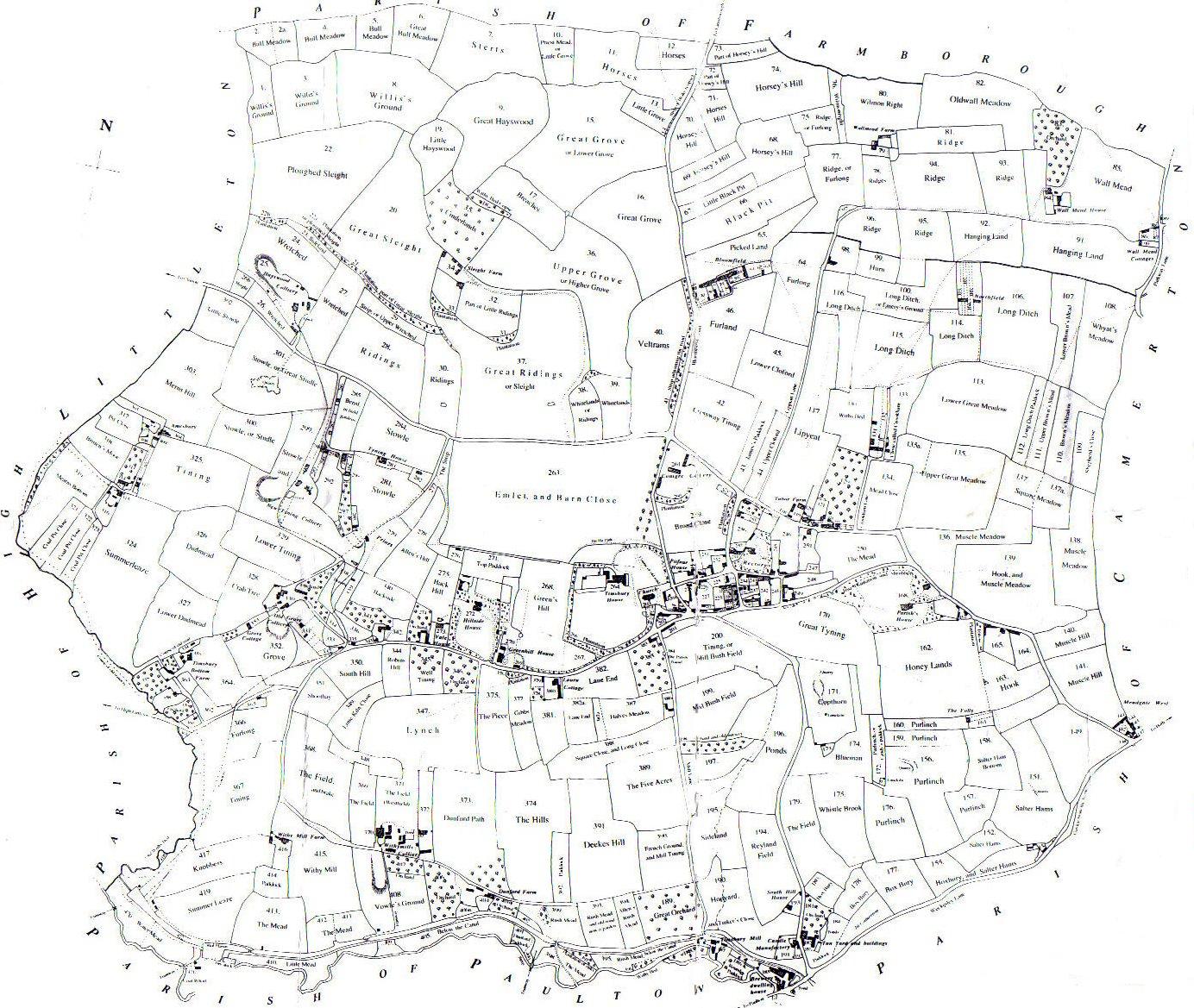
1838 Tithe Map of Timsbury
Tithe maps and apportionments were drawn up following the Tithe Commutation Act of 1836. Traditionally tithes were a local payment in kind of one tenth of the produce of land and levied for the upkeep of the local church and clergy. A landowner would therefore give the incumbent of the parish church eggs, wool, wheat, etc. With changes in tithe ownership and more extensive land enclosure, however, payment in kind was increasingly converted into a fixed sum of money. By the 19th century, there were wide variations in the method and level of payment of tithes across the country. Disputes were frequent, tithe payments were devalued by inflation and, increasingly, parishioners resented the payment of tithes. Resentments had a number of causes: tithes increasingly were paid to laymen, Nonconformists objected to supporting the Established Church and many powerful landowners viewed the payment of tithes as a restriction on innovation and growth. The Act replaced payments in kind with a rent-charge levied in accordance with the value of land and in proportion to the price of corn.

Ordnance Survey Maps 1844 to 1965
Historic maps of Bath and North East Somerset are now freely available online for the first time, thanks to the Know Your Place West of England project, supported by the Heritage Lottery Fund. The project’s website (www.kypwest.org.uk) displays modern and historic maps side by side, along with archive images and links, so users can explore their neighbourhood and see how it has transformed over time. Go to the Know Your Place website and scroll down and select Bath and North East Somerset. The map opens centred on Bath. You can scroll to move the map to Timsbury or use the Find button in the top left. On the right side at the top, select base maps and select the map you wish to view.